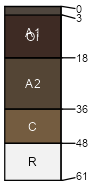
Bearcamp (40%)
Ridges
Typic Xerumbrepts
Well drained
Hydric: No
PAWS: 13 cm |

|
|
Brandypeak (30%)
Ridges
Typic Xerumbrepts
Well drained
Hydric: No
PAWS: 9 cm |

|
|
Woodseye (20%)
Frigid Mountains
Lithic Xerumbrepts
Somewhat excessively drained
Hydric: No
PAWS: 4 cm |

mountains / Summit mountain slopes / Shoulder mountain slopes / Backslope
|
|
Rock outcrop (2%)
Hydric: No
PAWS: NA |

|
|
Brandypeak <30% (1%)
Typic Xerumbrepts
Well drained
Hydric: No
PAWS: 8 cm |

|
|
Brandypeak >60% (1%)
Typic Xerumbrepts
Well drained
Hydric: No
PAWS: 8 cm |

|
|
Woodseye <30% (1%)
Lithic Xerumbrepts
Somewhat excessively drained
Hydric: No
PAWS: 3 cm |

|
|
Woodseye >60% (1%)
Lithic Xerumbrepts
Somewhat excessively drained
Hydric: No
PAWS: 3 cm |

|
|
Aquepts (1%)
Hydric: Yes
PAWS: NA |

|
|
Bearcamp >60% (1%)
Typic Xerumbrepts
Well drained
Hydric: No
PAWS: 11 cm |

|
|
Bearcamp <30% (1%)
Typic Xerumbrepts
Well drained
Hydric: No
PAWS: 11 cm |

|
|
Orthents (1%)
Excessively drained
Hydric: No
PAWS: 6 cm |

|
|