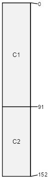
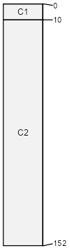
Xerofluvents-Xerorthents complex, 1 to 8 percent slopes, occasionally flooded
Xerofluvents
(50%)
Stream Channels and Floodplains
Well drained
Hydric: No
PAWS: 13 cm
arroyos / Backslope
Xerorthents
(35%)
Stream Channels and Floodplains
Well drained
Hydric: No
PAWS: 15 cm
Rock outcrop
(2%)
Hydric: No
PAWS: NA
hills
Riverwash
(2%)
Stream Channels and Floodplains
Hydric: Yes
PAWS: NA
channels
Dumps
(2%)
Hydric: No
PAWS: NA
Pits
(2%)
Hydric: No
PAWS: NA
San Timoteo
(1%)
Stream Channels and Floodplains
Hydric: No
PAWS: NA
mountains / Backslope
Unnamed
(1%)
Hydric: No
PAWS: NA
alluvial fans
drainageways
Xerorthents
(1%)
Stream Channels and Floodplains
Hydric: No
PAWS: NA
Wisflat
(1%)
Stream Channels and Floodplains
Hydric: No
PAWS: NA
mountains / Backslope
Arburua
(1%)
Stream Channels and Floodplains
Hydric: No
PAWS: NA
mountains / Backslope
Cortina
(1%)
Stream Channels and Floodplains
Hydric: No
PAWS: NA
alluvial fans
drainageways
Urban land
(1%)
Hydric: No
PAWS: NA
SSA
Scale
Published
Export
ca077
1:24,000
1990
2023-09-11