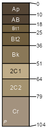
Alliance (85%)
Loamy 14-17 PZ
Aridic Argiustolls
Well drained
Hydric: No
PAWS: 25 cm |

broad interstream divides / Summit broad interstream divides / Footslope
|
|
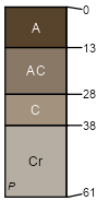
Rosebud (5%)
Loamy 14-17 PZ
Calcidic Argiustolls
Well drained
Hydric: No
PAWS: 16 cm |

broad interstream divides / Summit broad interstream divides / Backslope
|
|
Oglala (3%)
Loamy 14-17 PZ
Aridic Haplustolls
Well drained
Hydric: No
PAWS: 21 cm |

broad interstream divides / Summit broad interstream divides / Backslope
|
|
Duroc (3%)
Loamy 14-17 PZ
Pachic Haplustolls
Well drained
Hydric: No
PAWS: 30 cm |

|
|
Canyon (2%)
Shallow
Ustic Torriorthents
Well drained
Hydric: No
PAWS: 12 cm |

plains / Summit plains / Shoulder
|
|
Lodgepole (2%)
Clayey Overflow
Vertic Argiaquolls
Poorly drained
Hydric: Yes
PAWS: 34 cm |

|
|