Libeg-Macabre-Redchief complex, 35 to 60 percent slopes
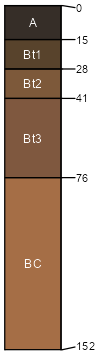
Libeg
(40%)
Upland Sagebrush Shrubland
Ustic Argicryolls
Well drained
Hydric: No
PAWS: 16 cm
alluvial fans
hills
terraces
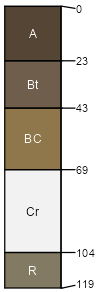
Macabre
(25%)
Upland Sagebrush Shrubland
Vitrandic Argiustolls
Well drained
Hydric: No
PAWS: 12 cm
hills
mountains
ridges
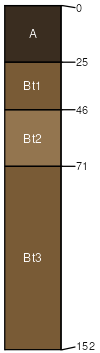
Redchief
(20%)
Upland Grassland
Ustic Argicryolls
Well drained
Hydric: No
PAWS: 13 cm
hills / Footslope
hills / Backslope
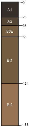
Monad
(4%)
Upland Grassland Group
Alfic Argicryolls
Well drained
Hydric: No
PAWS: 21 cm
stream terraces
Rock outcrop
(4%)
Hydric: No
PAWS: NA
Adel
(4%)
Upland Grassland Group
Pachic Haplocryolls
Well drained
Hydric: No
PAWS: 26 cm
drainageways
alluvial fans
Mollet
(3%)
Upland Grassland Group
Ustic Argicryolls
Well drained
Hydric: No
PAWS: 23 cm
fans
mountains
terraces
SSA
Scale
Published
Export
mt616
1:24,000
2003
2023-08-25