Springerville-Gem complex, 0 to 20 percent sloeps
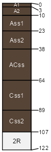
Springerville (60%)
Stony Upland 17-22 p.z.
Typic Chromusterts
Well drained
Hydric:
PAWS: 22 cm |

plateaus / Summit plateaus / Backslope
|
|
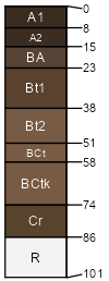
Gem (30%)
Stony Upland 17-22 p.z.
Typic Argiustolls
Well drained
Hydric:
PAWS: 7 cm |

plateaus / Summit plateaus / Backslope
|
|
Unnamed soils (10%)
Hydric: No
PAWS: NA |

|
|
| SSA | Scale | Published | Export |
| az643 | 1:32,000 | 1967 | 2024-08-30 |