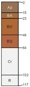
Badin channery silt loam, 2 to 8 percent slopes
Badin
(90%)
Acidic upland forest, depth restriction, dry-moist
Typic Hapludults
Well drained
Hydric: No
PAWS: 15 cm
interfluves / Summit
SSA
Scale
Published
Export
nc159
1:24,000
1996
2024-09-09