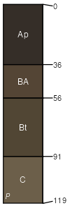
Apperson and Summit soils, 1 to 5 percent slopes, eroded
Apperson (65%)
Clayey Upland
Aquic Hapluderts
Somewhat poorly drained
Hydric: No
PAWS: 16 cm |

interfluves / Summit interfluves / Shoulder
|
|
Summit (35%)
Clayey Upland
Oxyaquic Vertic Argiudolls
Moderately well drained
Hydric: No
PAWS: 29 cm |

interfluves / Shoulder interfluves / Backslope
|
|
| SSA | Scale | Published | Export |
| ok131 | 1:24,000 | 1963 | 2024-08-27 |